 |
|||
|---|---|---|---|
| GPS Diary/01.01.2003 - 31.12.2003/London/UK | |||
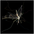
GPSdiary.org is an online archive of an art project, in which artist Thorsten Knaub recorded his daily movements over the course of a year by carrying a Global Positioning System(GPS)receiver on him.
The GPS utilises special satellites in the earths’ orbit to record any change of one’s position on the surface of the earth. Therefore any kind of movement will be charted according to the latitude and longitude grid system,
e.g. a walk to the local shop results in a small 'drawing', a day spent at home will be recorded as a dot only but a journey on the London Underground results in a straight line between the tube station where he is out of range of the GPS satellites.
GPSdiary.org makes it possible to view each days’ trajectory individually and hence follow the artists’ daily routine and movements.
For more information please see Press Release >PDF file< >Word.doc<
|
.GPSdiary by month PDF files(200k):
|
||||||||||||
|---|---|---|---|---|---|---|---|---|---|---|---|---|
| FEB 2003 | MAR 2003 | APR 2003 | MAY 2003 | JUN 2003 | JUL 2003 | AUG 2003 | SEP 2003 | OCT 2003 | NOV 2003 | DEC 2003 | ||
|
.Entire year
|
||||||||||||
|
.GPSdiary 2003 (1Mb)
|
||||||||||||
|
|
|||
|---|---|---|---|
| GPS Diary/01.01.2003 - 31.12.2003/London/UK | |||
 |
||
|---|---|---|
| JPG @ 300dpi (800k) | ||
| GPS Diary/01.01.2003 - 31.12.2003/London/UK(detail) | ||
|
Technical Info / Navigating GPSdiary.org |
|||
|---|---|---|---|
|
Browser & Monitor This site is optimised for Internet Explorer 5.0 or later, though all major browsers are supported as well.
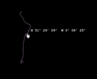
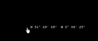
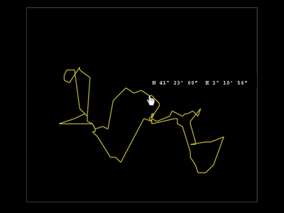
Finding your way around GPSdiary.org Moving the mouse pointer above a 'hot-spot' makes a latitude/longitude coordinate visible. This base or home coordinate marks the relevant start/end point of a journey. Hot-spots are invisible. Open ended journeys will have the coordinate information at the relevant endpoints of the day's travel. No movement outside the house is indicated as a dot. Base coordinates: Erlangen, Germany: N 49º 34' 51" E 11º 00' 29" Berlin, Germany: N 52º 31' 31" E 13º 23' 56" Barcelona, Spain: N 41º 23' 00" E 2º 10' 56"
Zoom in/out Shorter journeys have a zoom-in view, which will appear automatically when the mouse pointer enters the area of the line drawing. To hide the enlarged view again simply click anywhere within the framed area. As a rule of thumb, for most journeys under 2 km distance there will be a zoom-in view available. Additionally, enlarged views of some longer journeys as well as particular sections of some can be accessed with the mouse pointer in the same manner. Thanks for visiting & have a good trip!
|
 |
||
 |
|||
 |
|||
 |
|||
|
GPSdiary.org.
|
Info
|
|||||||||||||
|---|---|---|---|---|---|---|---|---|---|---|---|---|---|---|
|
|
..
.. |
|||||||||||||
|
|
||||||||||||||
 |
||||||||||||||